DNV GL RESOURCE MAP
Hello. I am a few sentences that quickly explain the purpose and functionality of the DNV GL Resource Map.
Lorem ipsum dolor sit amet, consectetuer adipiscing elit, sed diam nonummy nibh euismod tincidunt ut laoreet dolore magna aliquam erat volutpat


Click here to find out more about how this framework for benchmarking different oil and resources has been developed by DNV GL.

Go to resource map

Select up to 5 resources:
Expand to the
Detailed menu
View the
Category Menu
Conventional Oil (CO)
Light oil (LO)
Heavy oil (HO)
Unconventional Oil (UO)
Shale oil (SO)
Tight oil (TO)
Oil sands (OS)
Conventional Gas (CG)
Non-associated gas (NAS)
Associated gas (AG)
Unconventional Gas (UG)
Shale gas (SG)
Tight gas (TG)
Coal bed methane (CM)
Select a region and a country
Africa
MORE DETAILS
Asia/Australasia
MORE DETAILS
Europe
MORE DETAILS
FSU
MORE DETAILS
North America
MORE DETAILS
South &
Central America
MORE DETAILS
Middle East
MORE DETAILS

Select multiple regions:
Africa
Asia / Australasia
Europe
Former Soviet Union (FSU)
North America
South & Central America
Middle East

Clear all my selections
Click here to find out more about how this framework for benchmarking different oil and resources has been developed by
DNV GL.

: MORE DETAILS

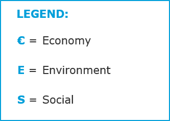
Economy

Resource size: Combination of resource size and recovery factor. A high score represents a large resource.

Economic impact: Economic effect on local communities, economic strength of the country is used as a proxy. A high score represents a large economic effect on the local community and a low economic strength of the country.

Break even cost: Combination of capex and opex. A high score represents a low break even cost.

Environment

Energy: Energy intensity for production of the resource. A high score represents low energy intensity.

Climate change: Greenhouse gas emissions due to greenhouse gas content in the resource as well as greenhouse gas emissions from the production processes including flaring. A high score represents low emissions.

Ecosystem services: Impact on biodiversity and ecosystem services as well as fresh water usage. A high score represents a low impact.

Local environmental impact: Combination of SO2 emissions due to sulphur content in resource; other air emissions related to production processes; spills to the environment; discharges to water and waste generation. A high score represents a low impact.

Social

Local content: Local content for production. A high score represents large share of local content.

Community impact: Community impact and engagement including labour practices and human rights in the country of operation, social strength in the country of operation is used as proxy. A high score represents a high social strength.

Corruption: Corruption level in the country of operation. A high score represents a low corruption level.

Safety: Combination of strength of safety regime and safety performance. A high score represents a strong regime and good performance.

Security: Security situation in the country of operation. A high score represents a good security situation.

Reserves (million BOE)

  
Click here to find out more about how this framework for benchmarking different oil and resources has been developed by DNV GL.
INFORMATION ABOUT OUR FRAMEWORK

DNV GL has developed a framework for benchmarking different oil and resources. In order to minimise the negative impact of oil and gas developments while maximising the positive impacts, a broader set of criteria is needed than the pure financial measurements used today.

Total impact = Economic impacts + Environmental impact + Social impact

Both positive and negative impacts are captured in the evaluation.

The resources have been classified according to the categories as defined in the overview below.


Oil
Conventional
  • Light
    Oil with low density, low viscosity, low specific gravity and high API gravity.
  • Heavy
    Oil with high density, high viscosity, high specific gravity and low API gravity.
Unconventional
  • Shale oil
    Synthetic petroleum produced from oil shale rock fragments
  • Tight oil
    Crude oil contained in petroleum-bearing formations of low permeability
  • Oil sands
    Sands containing a naturally occurring mixture of sand, clay, and water, saturated with a dense and extremely viscous form of petroleum
Gas
Conventional
  • Non-associated
    Gas reserves that are developed primarily to produce natural gas
  • Associated
    Gas produced as a by-product of the production of crude oil
Unconventional
  • Shale gas
    Natural gas that is found trapped within shale formations
  • Tight gas
    Natural gas produced from reservoir rocks with such low permeability that massive hydraulic fracturing is necessary to produce the well at economic rates
  • Coal bed methane
    A form of natural gas extracted from coal beds

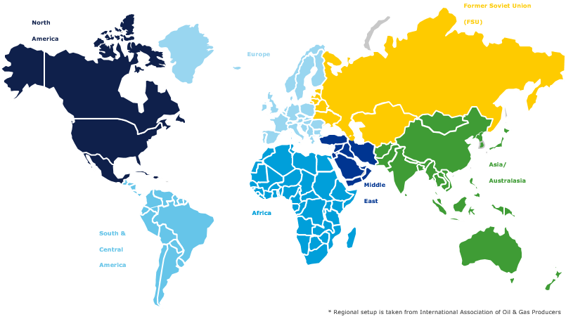
The result of the benchmark on a regional level has been visualized in the DNV GL Resource Map. The regions have been defined as illustrated in the figure below and the definition has been taken from International Association of Oil and Gas Producers.

Since the benchmark has been performed on a regional level, the data represents regional averages. Therefore there are countries as well as field developments that scores better and worse within each region.

In the DNV GL Resource Map, the user is able to compare up to 5 different resource types for one or up to all seven regions. The results are presented as traffic lights for the economic, environmental and social performance.

For each region there is a possibility to view a more detailed view of the benchmark and see what lies behind the traffic light results.

Back